Rig your Analysis Card
One sheet, folded like a book. Cover: your name, "Day 3," the date. Inside, write these four field labels. Leave room under each:
Three of these (the mapmaker, whose eyes, and the argument) are your exit ticket today. This is a real historian's tool: you're not just looking at the map, you're cross-examining it.
Something's Wrong
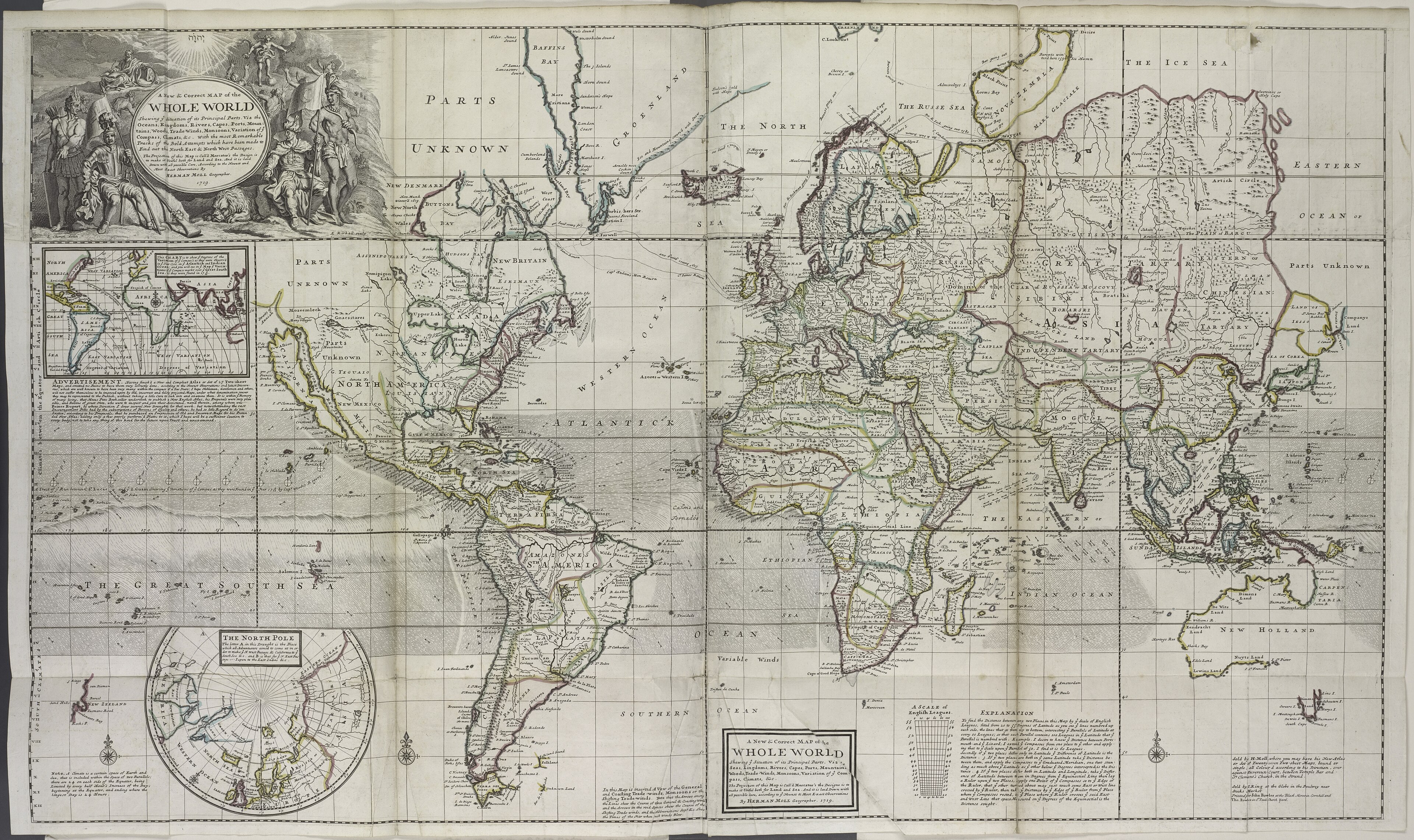
This is Herman Moll's "New & Correct Map of the Whole World," 1719, as new and correct as maps got. Except…
 Open the FULL map →
Zoom: Ctrl + scroll (or pinch). Bonus: the library mega-scan (huge, can be slow).
Detective hunt. Find what's wrong to modern eyes:
- Look at California, very closely. What did Moll do to it?
- Find the words "PARTS UNKNOWN." Now find them again, somewhere else. How many can you spot?
- Bottom-right: find the continent that just… stops, like the artist put the pen down.
- What does Moll call the Pacific Ocean? (Hint: it's huge, bottom-left.)
Sharp-eyes bonus: find the round inset map of the North Pole, a big circle labeled "THE NORTH POLE," bottom-left, below the tip of South America. Why would Moll draw the pole separately instead of on the main map? (Day-2 clue: what does Mercator do to the top and bottom of the world?)
Big idea: these aren't just goofs. They're what people in 1719 believed. And what they wanted to believe. That's the whole point of today.
The Argument in the Picture
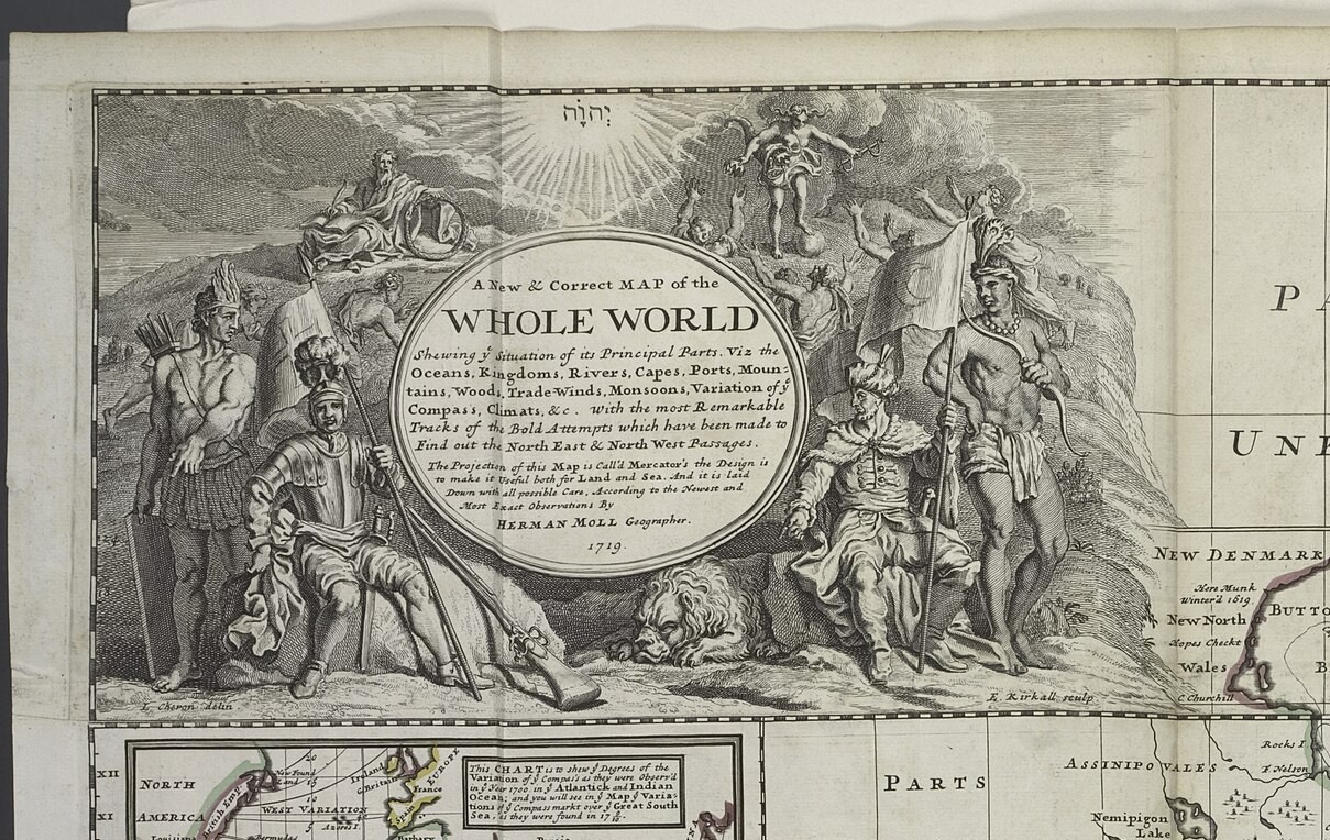
A map argues with more than coastlines. Look at the fancy artwork in Moll's title box, the top-left corner. Every figure in it is making a claim about who runs the world.
 Open it big →
Read the picture. Find:
- Who's sitting comfortably, in armor, like they own the place? And who's standing at the edges, half-dressed, holding a bow?
- Up in the clouds, someone shines down over the whole scene. Who does the mapmaker put above everyone?
- Find the lion. Find the person with the bow, and the person with a flag. What is each one supposed to say about its part of the world?
The figures at the edges (the bow, the feathers) stand for the "new" lands. Notice they're drawn as scenery or servants, never in charge. That's an argument, made in a picture.
Flip the Map
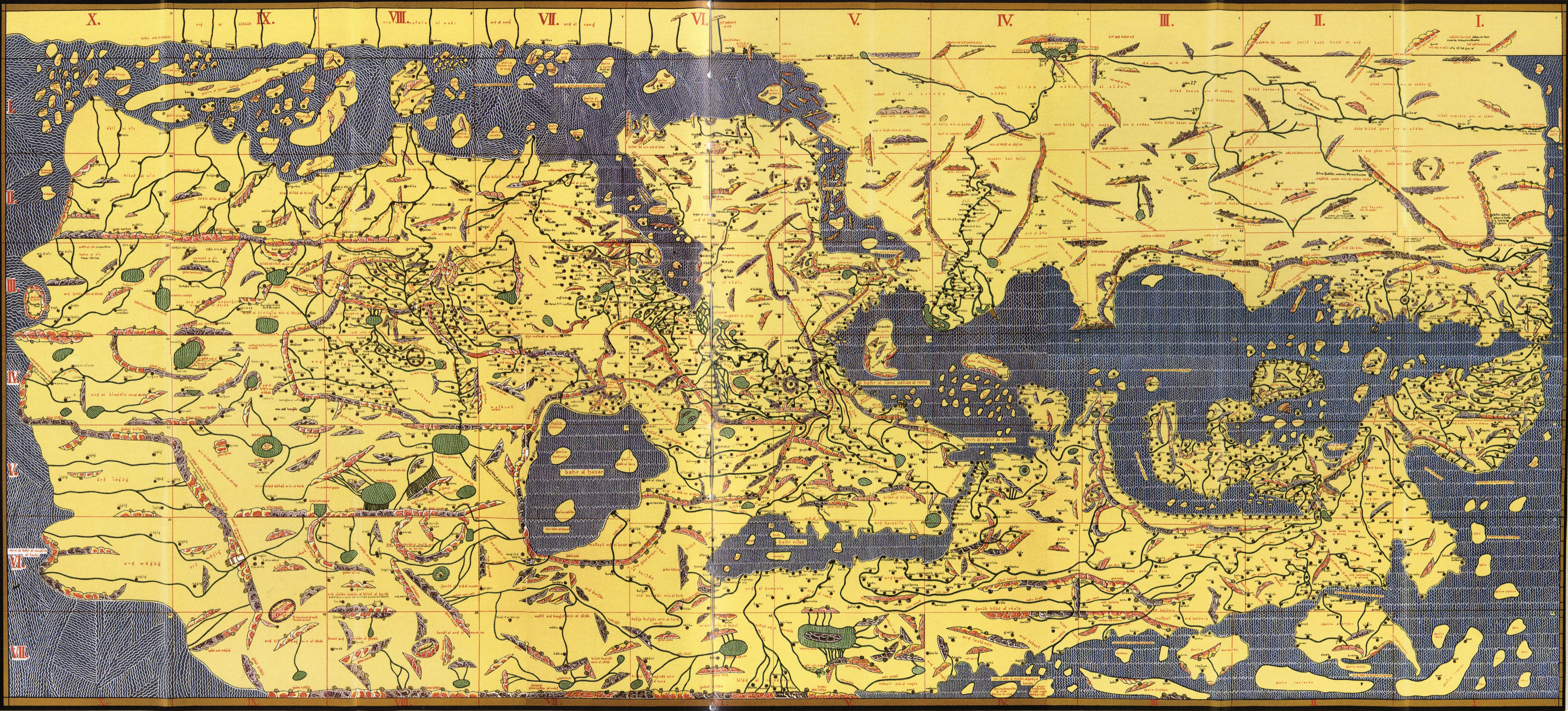
Here's a world map made ~560 years before Moll's, by a mapmaker named al-Idrisi, working for a king in Sicily in 1154. Something about it will feel wrong to your eyes. It isn't. It's just drawn from a different point of view.
 Open it big →
- Which way is up? Al-Idrisi drew his map with SOUTH at the top. There's no law that north goes up. It's a choice, and he made the opposite one.
- Near the top-center he put the places he thought mattered most: Arabia and North Africa, his world. Every mapmaker centers their own.
- So back to Moll: he put Europe big, up near the top, north-up. Whose world is Moll's map centered on?
Fill the Blank
Moll's map is covered in places named "New" (New England, New Britain, New Holland) plus big spaces stamped "Parts Unknown." New to whom? Unknown to whom? People already lived there. Let's put them back on the map.
Open Native-Land.ca →- On Moll's map, find two places starting with "New." Someone renamed them. Who was there first?
- On native-land.ca, search our town: Salem, MA. Whose land is this? Let the map tell you.
- Now search a spot Moll stamped "Parts Unknown" (try the middle of North America). It was never empty. Just unknown to Europeans.
Even native-land.ca calls itself "a starting point, not the final word", because it's a map too, and every map is somebody's argument. Including that one.
The Whydah's World
Back to Moll one last time. He drew this two years after our ship went down, and her whole world is on it. Find the three places:
- GUINEA: the West African coast she was built to sail to, to buy enslaved people. (She's named for a port there: Ouidah.)
- The Caribbean: where she delivered them, and where Bellamy's pirates later captured her.
- New England: not a stop on the slave route. It's only where the pirates sailed her afterward, and where she wrecked and still lies (yesterday's live-cam water).
Make Your Case
Finish THE ARGUMENT on your card like a historian. A claim, backed by evidence:
"This map argues that ______
because I can see ______ on it."
- Walk your sentence up to the board when Mr. Howe calls for it. Every crew's claim goes up.
- Then stand on the line. One wall = "MOLL made this map." The other wall = "the EMPIRE that paid for it made it." The pirates who fed him the intelligence? Somewhere in between. Go stand where you believe, and be ready to defend your spot.
There's a real case for each: a map has a mapmaker, a source, and a paymaster. So who really made it?
cartographer = a mapmaker · empire = one country ruling lands and people far away · intelligence = secret, valuable information · argument = a claim a map (or anything) is trying to prove